
Sediment Monitoring and Discharge Measurement
Sediments are an integral part of all river systems, linked to both the physical and chemical attributes of a catchment. Sediments contribute to the form and physical characteristics of river channels and aquatic habitats and are essential for the transport and storage of nutrients. They also reflect the energy and timing of a river’s flow regime.
The sediment supply to floodplains, deltas, lakes, and oceans is closely related to the amount of sediment transported by the rivers. Sediment redistribution within a river system has long been recognised as one of the critical factors for the development of river basins. Low-lying flood plains and delta environment are particularly sensitive to changes in sediment transport. Thus, detailed knowledge of sediment transport conditions is necessary for predicting the future development of the river and for planning purposes.
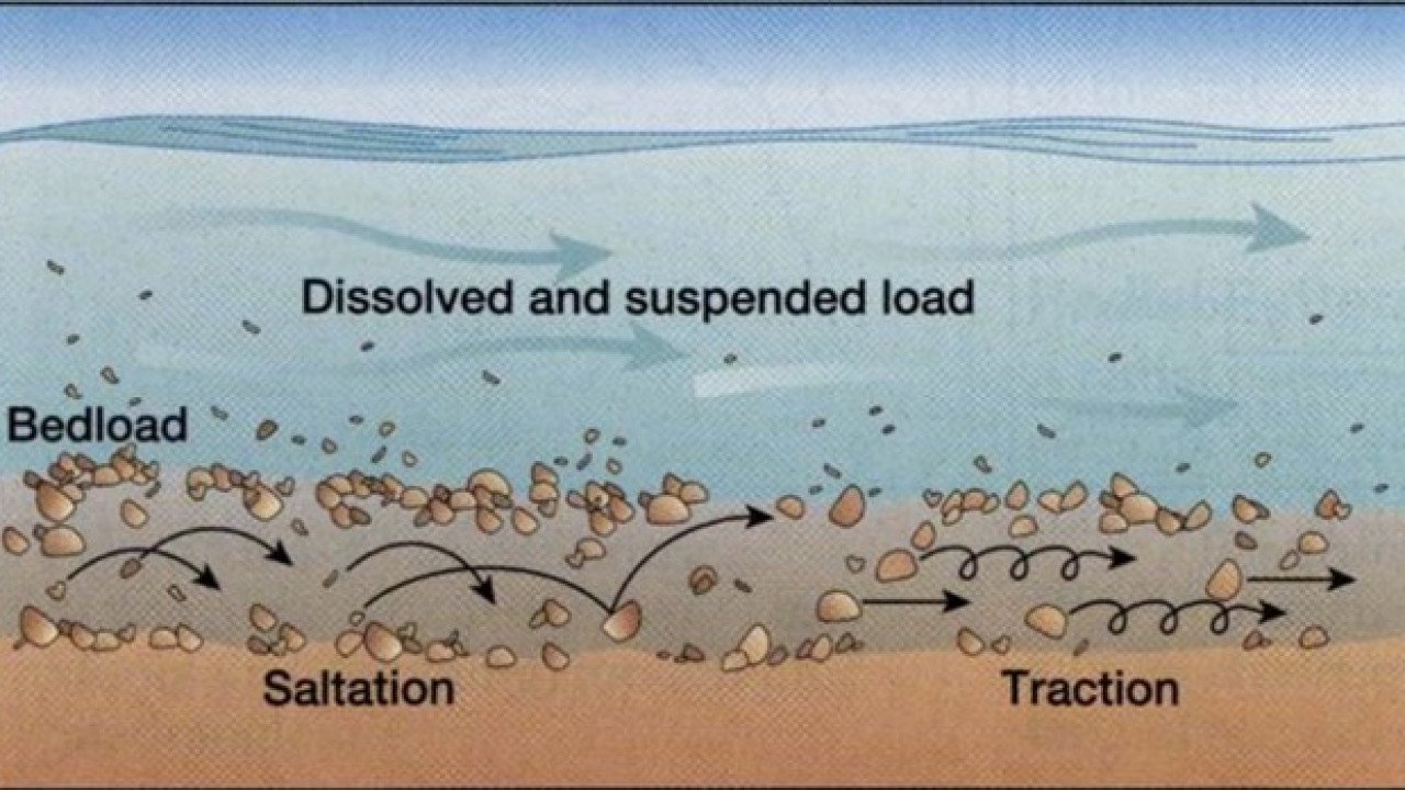
Tributary flows and catchment characteristics partly control the amount of sediments delivered to the Mekong River. Monsoons and associated flow patterns drive the delivery of sediments to the river and transport material through the system. Very fine material is carried through the system and into the sea where its nutrient content underpins marine ecosystems and commercial fisheries. Slightly coarser material may end up on flood plains and riverbanks, where it serves to fertilise riverbank gardens and floodplain farms. Sands and gravels may take years and even decades to be transported through the system, stored temporarily in channels, riverbanks, or bars, where they create stable and resilient structures that provide important ecological habitats. Sand-sized material is also critical for maintaining the stability of channels in the lower river and delta.
The discharge and sediment loads of the Mekong have been significantly altered due to natural processes, hydrological changes, and human activities such as land-use (deforestation, soil conservation measures), groundwater pumping, irrigation, sand mining, and dam structures.
In the Upper Mekong Basin (UMB) upstream of the Chinese border, the mainstream has been harnessed through the development of a cascade of hydropower stations, and many additional hydropower developments are in various stages of development in both the LMB mainstream and tributaries. Although the reservoirs in both the UMB and LMB have trapped most of the sediment, information on the impact of dams on sediment load, especially in the LMB, is limited. Sands, gravels, and pebbles are extracted and used for landfilling and construction materials locally, and also provide the basis for an export industry.
Understanding sediment characteristics and the relationship between sediment transport processes and the flow regime is necessary to quantify the status of a river and to understand or predict how future developments may alter existing conditions.
MRC Interventions
Discharge and Sediment data collection has been an MRC activity since the Mekong Committee was established in 1957. Monitoring measures discharge and sediment transport in the mainstream of the Mekong River to provide an understanding of the physical processes occurring within the river. This activity provides a significant amount of data and information for project development, design and research.
Recognising that development activities in the Mekong River Basin have the potential to alter the hydrological, physical, and ecological attributes of the river, which in turn could have economic and social impacts, the MRC developed the Discharge and Sediment Monitoring Program (DSMP) in 2009. The DSMP provides the Member Countries with the equipment and skills required to obtain high-quality sediment measurements to understand sediment transport in the Mekong River.

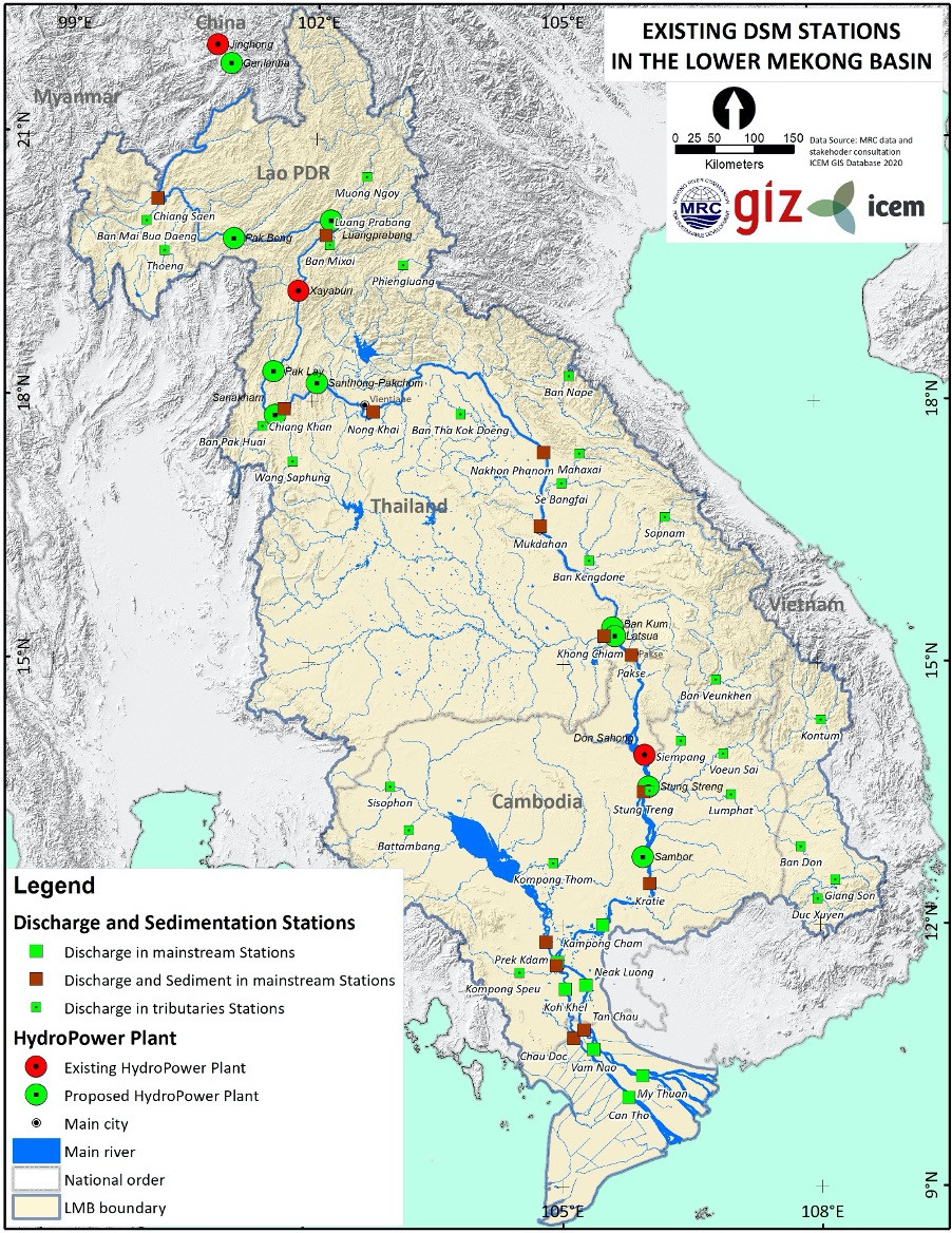
The DSMP measures discharge and suspended sediment concentration (SSC) at 17 sites along the mainstream Mekong, the delta, the Tonle Sap River, and the Sekong River. DSMP monitoring consists of:
- Daily recording of water levels
- Measuring discharge levels on a weekly, bi-weekly, or monthly basis depending on the flow rate
- Collecting suspended sediment samples
- Determining bed loads and sediment grain-size at a subset of the site
- Surveying cross-section channels on a bi-annual basis (wet season, dry season)
Since 2014, monitoring had been discontinuous, with respect to timing and sampling sites. Data are available for part of 2014 to 2015. Due to the organisational reform, from 2016 to mid-2018 discharge and sediment monitoring could not be conducted. Monitoring at all sites was recommenced in June 2018 and monitoring at additional sites near the Xayaburi, and Don Sahong hydropower projects has recently begun under the Joint Environmental Monitoring Project (JEM).
The current implementation plan for the DSMP indicates higher frequency sampling (weekly) in the wet season (June-October). The monitoring is carried out by line agencies of the Member Countries and reported on a semi‐annual or annual basis.
Contribution to Basin and National Planning
The MRC’s discharge and sediment monitoring data contributes to:
- Preparation of strategic planning at national and regional levels, and the development of research
- Implementation of the MRC’s Procedures for Data and Information Exchange and Sharing (PDIES) and the Procedures for Notification, Prior Consultation and Agreement (PNPCA)
The MRC’s sediment and discharge data are available online.