OUTCOME 6: MONITORING & FORECASTING
Basin-wide Monitoring, Forecasting, Impact Assessment, and Dissemination of Results Strengthened for Better Decision-making by the Member Countries
INDICATORS • The extent to which line/implementing agencies use MRC reports and information systems for better decision-making • Quality (timeliness and accuracy) of MRC forecasting information in critical or emergency situations
HIGHLIGHTS The MRC has made progress during 2016–2020 with respect to upgrading and maintaining its monitoring, forecasting, modelling, and data and information management systems, and in establishing a comprehensive and replicable assessment and reporting framework through the redesigned SOBR and MRB-IF. Its Mekong-HYCOS hydromet network, which provides basin-wide automated and near real-time water level and rainfall data, is now composed of 51 HYCOS stations and 13 drought stations on the Mekong mainstream and major tributaries. It has continuously improved its routine environmental monitoring, which comprises WQM, EHM, and FM as well as its regional reporting, which includes annual hydrological/flood/drought reports, WQ reports, annual FADM reports, and status and trends of ecological health in the LMB. It commenced the MRC’s JEM Programme, a first of its kind with the implementation of pilot projects in Xayaburi and Don Sahong hydropower dams. The JEM Programme is expected to elevate joint cooperation and enable MCs to monitor, assess and mitigate with more certainty impacts of specific mainstream HPPs. The MRC Regional Flood Management and Mitigation Centre (RFMMC) was upgraded to the RFDMC in 2017 to include drought services, and continued to provide river monitoring, timely flood and drought forecasting, and early warning information throughout the year to MCs and potentially impacted communities. The increase in quality and amount of detail in the monitoring and forecasts, and hydrological conditions reports (i.e. that illustrate more clearly the magnitude and spatial extent of the flooding and drought conditions) is leading to the more mainstream use of these forecasts by relevant agencies in the MCs, news agencies and social media. This improved ability by the MRC to disseminate timely and quality forecasts of extreme basin and river conditions such as flooding, low flows, and droughts is contributing to protecting properties and saving lives in the Basin during these extreme conditions. Throughout 2016–2020, the MRC continuously provided the MCs’ technical support services in the areas of data and information management, modelling, and assessment. These services include the upgrade and continuous operation and maintenance of the MRC Information System (MRC-IS), the Data Portal, the DSF and related tools. These services are certainly crucial in supporting the MRC in basin-wide and project assessments, and the MCs in capacity building and in sub-basin planning, and in informed and scientifically based decision-making. There are notable gaps and challenges, however, in these core functions of the MRC. Accordingly, a major exercise was launched in 2019, and approved by the Joint Committee, to strengthen the organization’s systems relating to monitoring/data collection, data and information management, modelling, forecasting and assessment, and information visualization and dissemination. Implementing the Design Concept would put the MRC in a more capable position to exercise its core river functions and address the pressing needs of the present and future.
River, environmental, and socio-economic monitoring In support of river monitoring, the MRC has upgraded and expanded the Mekong-HYCOS Hydromet Network, which provides basin-wide automated and near real-time water level and rainfall data. The network now includes 51 HYCOS stations and 13 new drought stations on the Mekong mainstream and major tributaries: 13 HYCOS stations in Cambodia, 17 in Lao PDR, 11 in Thailand, and 10 in Viet Nam. Corresponding numbers for drought stations are 3 in Cambodia, 5 in Lao PDR, and 5 in Viet Nam. The new Xiang Kok station, which is located downstream of China’s Jing Hong station, is important because it gives the MRC more lead-time to monitor and prepare in case of emergency flood situations. In conjunction with China’s Jing Hong station, the new Xiang Kok station will also provide additional data for monitoring the flow contribution of the Upper Mekong basin. The Ban Pakhoung station, downstream of Xayaburi, was added as part of the JEM Programme pilot testing. The network includes rainfall and water level data manually shared by China for two stations in the upper Mekong (i.e. Lancang River) as part of a data sharing agreement with the MRC that began in 2002. MRC flood forecasting also benefits from 124 rainfall stations across the lower reaches of the basin. The expansion plan of the Hydromet network includes adding five stations: 1 station in Cambodia located at Koh Key; 2 in Thailand located at Bung Karn and Amnat Charoen; and 2 in Viet Nam located at Tra Vinh and Dai Ngai, which were delayed due to the COVID-19 pandemic.
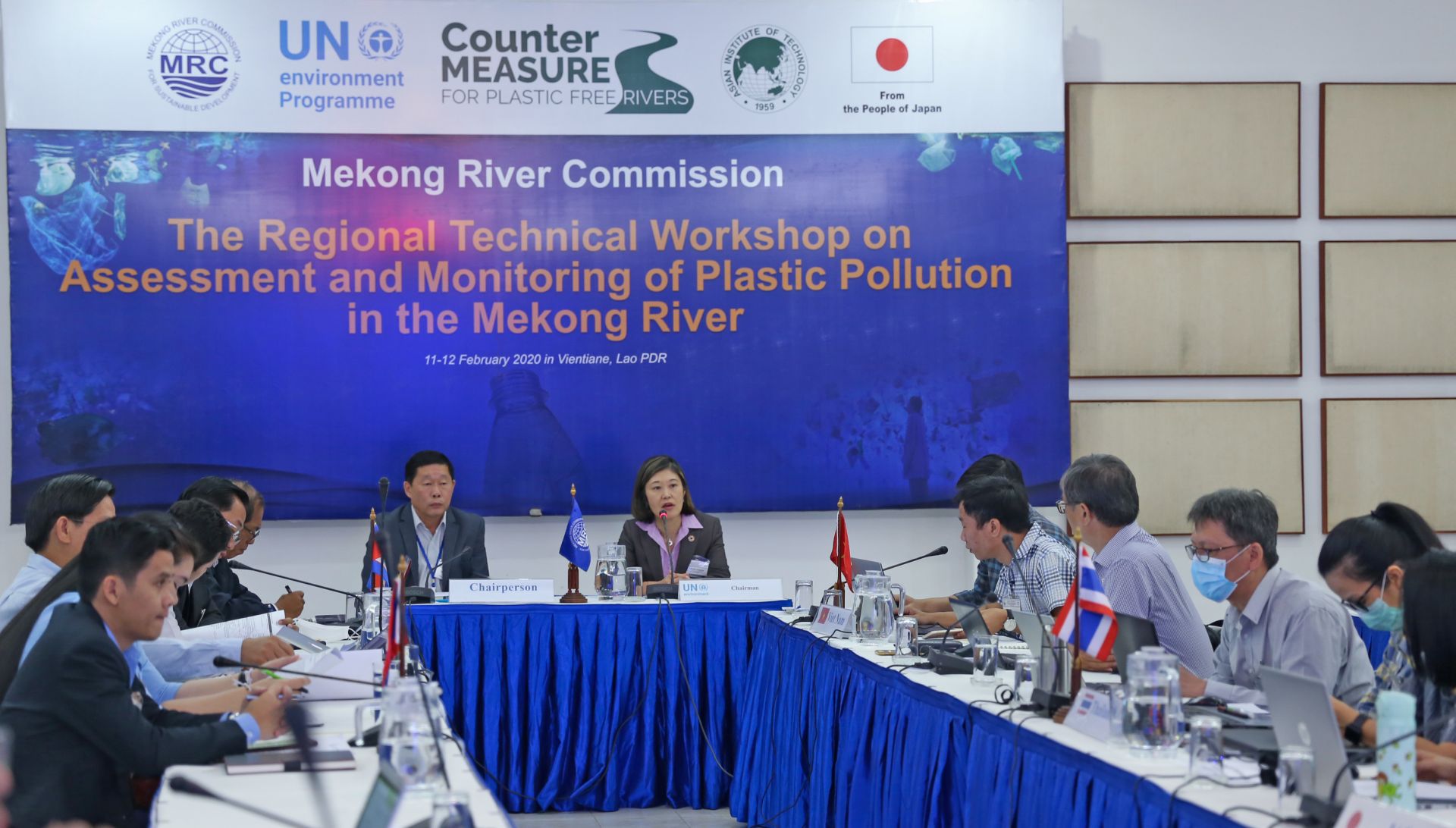
Senior officials from the MRC Member Countries and UNEP meet to discuss a joint project to assess and monitor plastic pollution in the Mekong River (February 2020).
Throughout 2016–2020, the MRC performed its routine environmental monitoring services, which include WQM, EHM, and FM. It also prepared reports such as the annual regional WQ reports, biennial routine EHM reports, the regional report on status and trends of ecological health in the LMB during 2011–2019, and a technical paper on the status and trends of fish abundance and diversity in the LMB during 2007–2018. The MRC is monitoring monthly a total of 48 WQ stations: 17 mainstream stations, 5 stations in Bassac River, and 26 stations in tributaries. A total of 41 EHM stations (8 stations in Lao PDR, 17 stations in Cambodia, 8 stations in Thailand, and 8 stations in Viet Nam) are monitored on a biennial basis during March-April of each monitoring year. For fish monitoring, the MRC is monitoring 38 sites for fish abundance and diversity, 8 sites for fish larvae and drift, and 15 rows for Dai fishery. The JEM Programme has elevated joint cooperation and is enabling MCs to monitor, assess and mitigate with more certainty impacts of specific mainstream HPPs. Together with the JEM Programme document, the MRC produced also two pilot project proposals, for Don Sahong and Xayaburi HPPs. These pilot projects involve testing the proposed monitoring approaches for the five key disciplines: hydrology and hydraulics, sediment and geomorphology, water quality, aquatic ecology, and fish and fisheries.
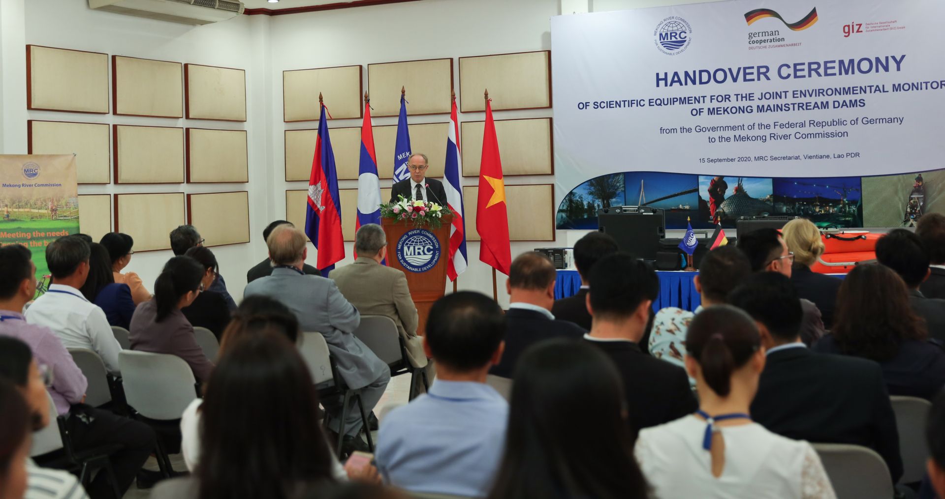
H.E. Mr. Jens Peter Lutkenherm, German Ambassador to Lao PDR, addresses the Handover Ceremony of the JEM project equipment from GIZ to the MRC Secretariat and the Lao National Mekong Committee (15 September 2020).
The MRC’s SIMVA monitoring system enables the organization to assess the status and trends of the socio-economic conditions of the people in the Basin. Following the various national and regional meetings to review and analyse the results of the SIMVA 2018–2019 survey on households and communities in the Mekong mainstream, the Tonle Sap and the Mekong Delta, the SIMVA Regional Report highlights the main changes in the Mekong corridor livelihood options, their level of dependency on the river, and coping strategies to changes in the river water-related resources. The Regional Report also compared the livelihood and well-being situations, and respective coping strategies in 2018–2019 with those in 2014 and 2011. The results of the SIMVA survey with 2,800 households in 200 villages indicated that communities in the Mekong mainstream corridor were still largely dependent on the river water-related resources for their livelihoods, income, and well-being. As such, they were still vulnerable to changes in the Mekong water resources. However, the overall dependency decreased with other, non-water resources-related livelihood activities, such as wage employment and business/trading, which play increasingly important roles in their overall livelihood strategy. The survey results also showed that, while government support and provision of basic infrastructure services (e.g. roads, schools, community health clinics, and water and sanitation) are critical in helping households to cope with vulnerabilities, there is still significant room for improvement in the production-related support services. Decentralisation of CRBMF activities, including river, environmental and socio-economic monitoring (i.e. HYCOS, WQM, EHM, FM, and SIMVA), has been a major focus of SP 2016–2020. Although there has been some good progress, the transition period has been challenging and resulted in calls from a wide range of stakeholders to reconsider the approach, particularly the pace. Nevertheless, recognizing the importance of the data and information to the CRBMFs, all MCs made a strong commitment to the decentralization process and took commendable steps to take on greater responsibility for the monitoring activities in difficult circumstances. Three of the eight monitoring activities had been completely handed over to MCs as of December 2018: (i) near real-time monitoring of hydro-meteorological parameters (HYCOS stations); (ii) manual rainfall and water level monitoring (other hydro-met stations); and (iii) ad hoc provision of socio-economic data for basin planning.
Flood and drought forecasting The MRC RFDMC provided river monitoring, flood and drought forecasting and early warning information throughout the year to MCs and potentially impacted communities. The Centre completed the development the flood forecasting website and the drought forecasting and early warning (DFEW) website. It also provided flood and drought forecasting services through forecasting traditional bulletins, reports, and other advisories (see Figures 38 and 39). In addition to providing the forecasts and advisory services year-round, the MRC Secretariat and the RFDMC continued to enhance, operate, and maintain the database and modelling systems that underpin such services.

Figure 38. MRC home page showing daily flood forecasts during the wet season (June - October)
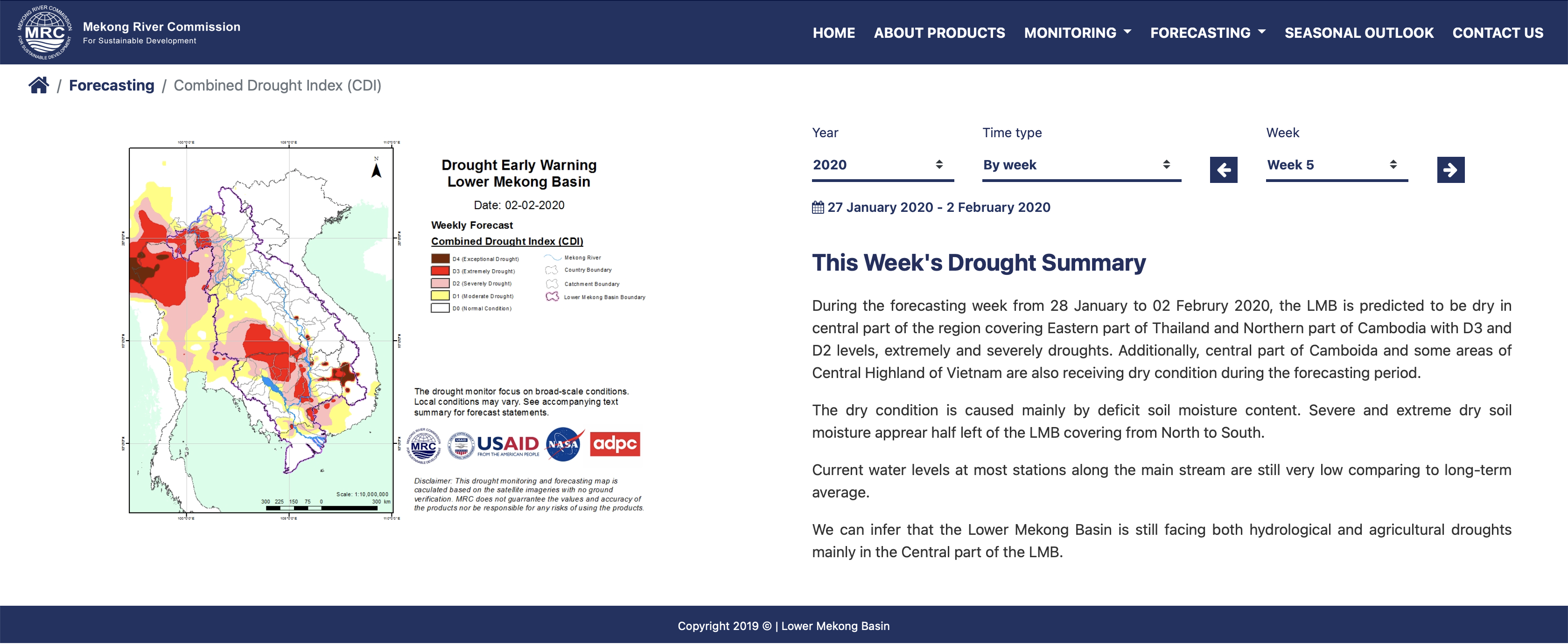
Figure 39. The MRC Drought Forecasting and Early Warning website shows weekly drought conditions in the Lower Mekong Basin
Data and information management, assessment and modelling systems In addition to river monitoring and flood/drought forecasting, over the years, the MRC has provided technical support services to the MCs in data and information management, modelling, and assessment. These services include the continuous operation and maintenance of the MRC-IS, the Data Portal, the DSF and related tools. The Data Portal, which represents the online presence of the MRC IS, allows MCs and others to retrieve regional data and information to support informed regional sustainable basin planning and decision-making. In March 2020, MRC deployed a new improved version of the Data Portal, hosting over 10,000 datasets. The MRC has also continued to maintain the MRC DSF. For the Council Study, the DSF was also loosely linked with the DRIFT software to provide the values for a given set of hydrologic, hydraulic, WQ indicators that were subsequently used to estimate corresponding ecosystem changes in response to these changes in hydrologic/hydraulic and water quality conditions.
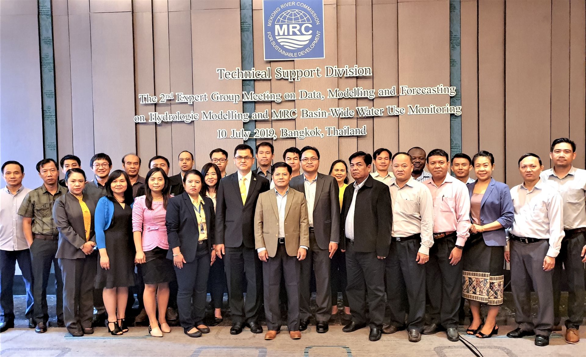
The 2nd Meeting of the Expert Group on Data, Modelling, and Forecasting discusses hydrologic modelling and basin-wide water use monitoring, July 2019.
System reinvigoration
The MRC Secretariat worked with partners and countries to review the current MRC systems and related tools, and to prepare a high-level design concept for a reinvigorated and integrated system (see Figure 40).
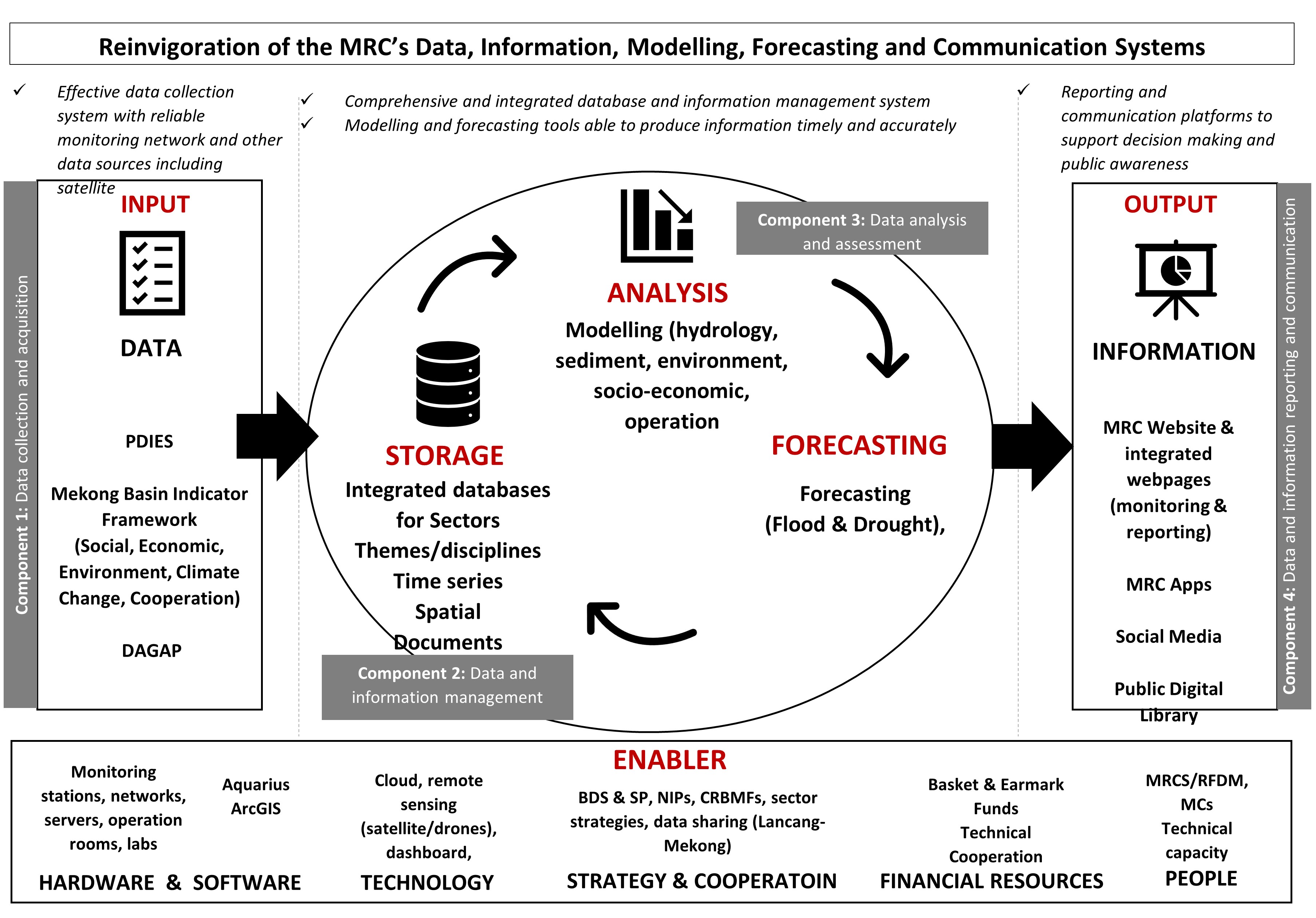
Figure 40. Architecture of main elements of the reinvigorated MRC’s data, information, modelling, forecasting, and communication systems
Evidence of change
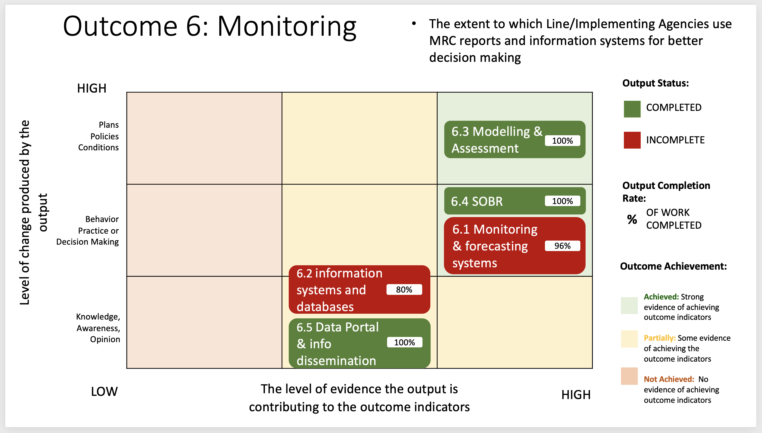
Figure 41. Outcome Evaluation Matrix
Note: The Matrix assesses outcome achievement based on output completion and the type of change that occurred – Outcome 6
Use in regional and national planning and decision-making There is ample evidence of the use of MRC systems to access basin and river monitoring data, and flood and drought forecasting information. At the regional level, the data collected and assessed were used in the MRC’s activities, including critical ones such as the preparation of the State of Basin Report, the Council Study, and PNPCA assessments. There is strong interest in flood forecasting information, as indicated by the number of times that the flood forecasting website has been accessed. River communities are beginning to use hydrological monitoring data upstream of the river to determine potential for flooding or extremely low flow conditions that may impact agriculture and water use. MC’s use of the MRC’s food forecasting services is further evidence of their increasing mainstreaming. On a routine basis, the MRC Secretariat shares flood information via email to the national focal points of relevant national line agencies. In turn, these agencies disseminate information to a wider audience at the national, sub-national and local levels. To illustrate, during the rainy season (June to October), the RFDMC issues around 150 daily flood forecasting bulletins. These daily bulletins are distributed to 190 stakeholders including national line agencies, educational institutions, NGOs, the private sector, and the public. Around 30 weekly river monitoring bulletins are distributed during the dry season (January – May, and November – December). Around 310 flash flood bulletins are uploaded on the FFGS website during the rainy season. Based on the performance evaluation of FFGS in 2020, the Probability of Detection is 60% accurate, indicating that 40% of the forecast flash flood events did not occur. The weekly drought conditions presented in the DFEW website have been incorporated into the weekly flood situation report and widely shared with the public since September 2020. This integrated report is an essential source of information not only for the NMCs and line agencies, but also for research organizations, academic institutions, and other national and regional organizations. The Data Portal is used not only by the MCs, but also by a wide range of stakeholders including research and educational institutions, NGOs, the private sector, and the public. Based on the number of visits by users, its usage rate has remained steady, although the rate of data downloads flattened in 2016 (see Figure 42). In 2020, which was the final year of the SP 2016–2020, there appeared to be a renewed interest as indicated by an acceleration in the rate of the data downloads. It should be also noted that an improved version of the Data Portal was launched in 2020.
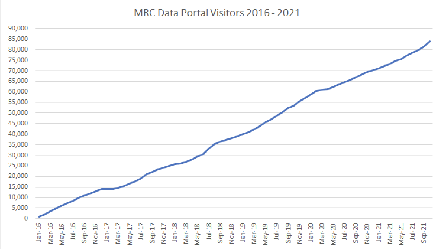
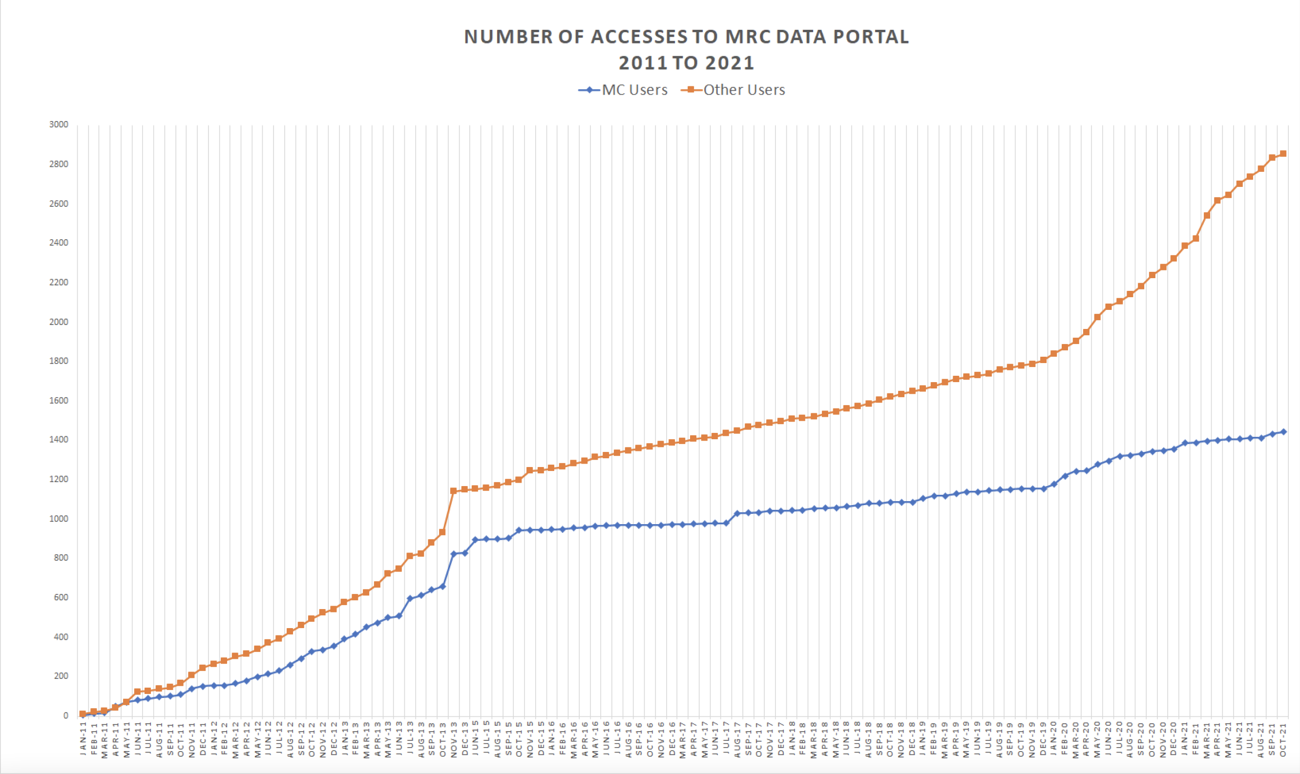
Figure 42. Numbers of accesses (above) and visitors (below) to the Data Portal, 2016–2020
Recent high-profile studies on the Mekong situation and impacts of water infrastructures use MRC’s data and information. The MRC Secretariat’s own report is also widely quoted in the media and the public, discussed and referred to it. It helps inform debates on the facts and fiction of the situation, illustrating the knowledge brokerage role of the MRC.
The MRC DSF models and tools are continuously being used by MCs in national projects and studies. The Lao National Mekong Committee (LNMC), for example, has used the DSF models, which included data and results from the Council Study, to support the development of river basin management plans in key tributaries of Lao PDR. The MCs have continuously applied DSF in national pilot projects to build and maintain their modelling capacity, and benefited from the Associate Modeller Programme, whereby young modellers from the countries were trained and worked in the MRC Secretariat.
Reliability and quality of information
MRC’s concerted efforts since 2018 to address the operation and maintenance issues that plagued the proper functioning of the HYCOS stations in prior years, in particular during the 2014–2017 period, have dramatically raised the level of performance of the Mekong-HYCOS Hydromet from its low in 2017 (see Figure 43). Moreover, the increased maturity in the workflow processes for field maintenance visits and related operation and maintenance tasks, combined with improved capacity of the national routine monitoring teams, were crucial in keeping the system operational and functioning properly. These improvements in the level of performance of the HYCOS stations may be also attributed to the MRC and MCs, which eventually resolved many of the operational issues that beset the early implementation of decentralization activities.
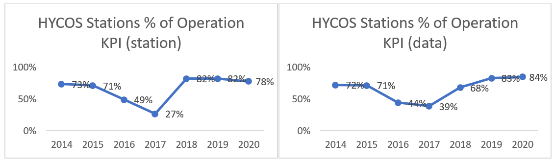
Figure 43.* Annual average level of performance of the Mekong-Hycos Hydromet Network in the Lower Mekong Basin from 2014 to 2020 (percentage of stations in operation, and percentage of data transmitted automatically) Note: 100% of the data are recorded and transferred manually.
In an effort to improve the accuracy of the forecasts, the RFDMC has continued to evaluate and disseminate their accuracy. In general, the accuracy of Day 1 to Day 3 forecasts are within 80–90 percent of the observed values, except for the areas between Paksane and Mukdahan, which have been influenced by the Nam Ngeum hydropower operation since 2011. Except for the areas between Chiang Khan and Nong Khai, the accuracy of the Day 4 and Day 5 forecasts are within 30–60% of the observed values. Finally, the increasing quality and amount of detail of the information presented are certainly improving the confidence of the users in these forecasts. The interactive graphs and maps that are now standard content elements of the forecasts further enhance the quality and effectiveness of the reporting because they illustrate more clearly the magnitude and spatial extent of flooding or drought conditions. This has led to the more mainstream use of these products by relevant agencies, in the MCs, news agencies and social media.
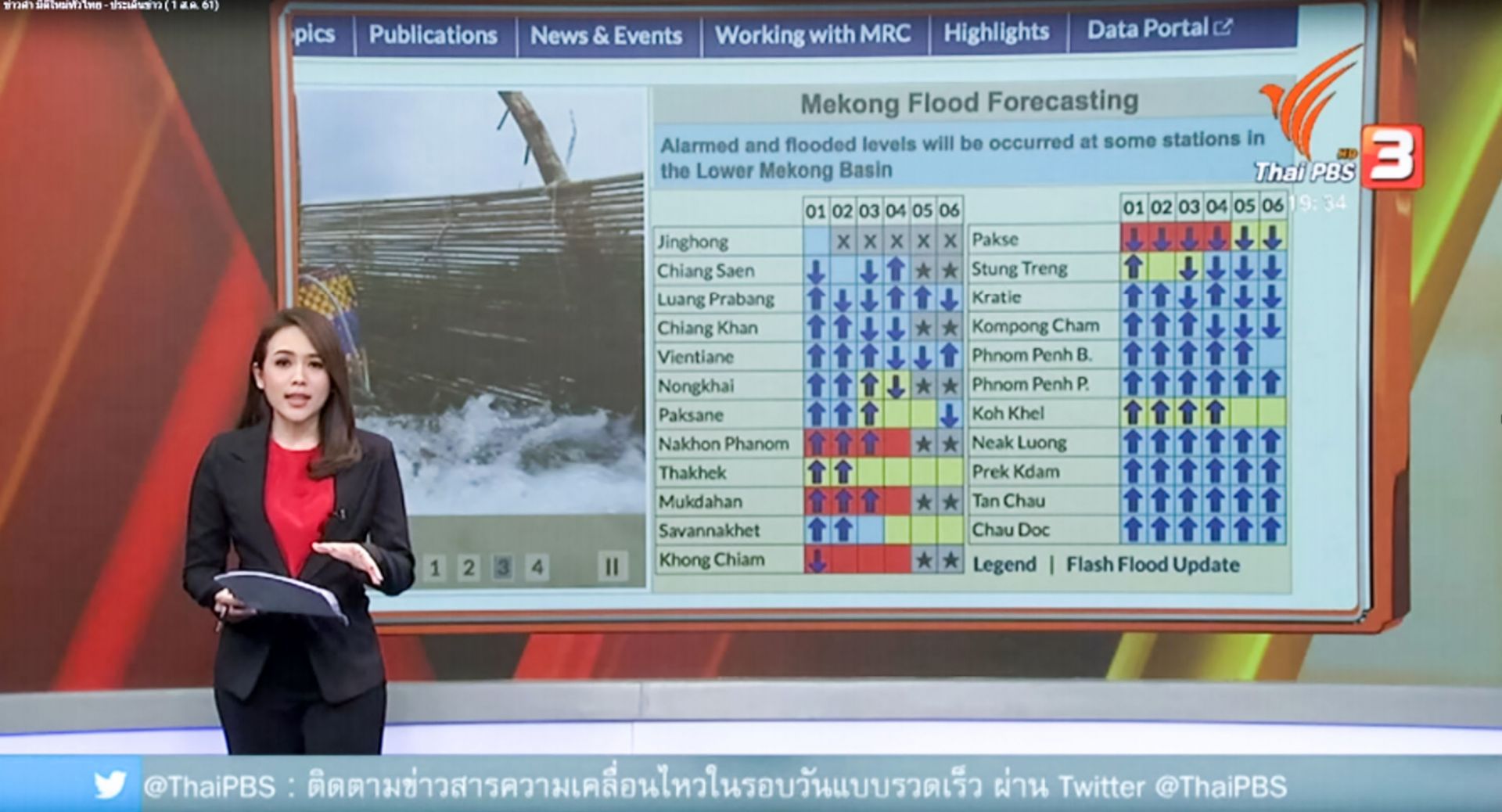
The Thai Public Broadcasting Service uses the flood forecasting from the MRC’s website during its news reporting on the flood situation in the aftermath of tropical storm Son-Tinh (1 August 2018).