OUTCOME 3: GUIDELINES
Guidance for the Development and Management of Water and Related Projects and Resources Shared and Applied by National Planning and Implementing Agencies
INDICATORS:
• Number of transboundary national and provincial projects applying MRC guidelines • Evidence of national and basin benefits in using MRC guidelines and standards
HIGHLIGHTS To support the MCs in employing best practices for project planning, design, and implementation, not only to enhance project benefits at the national level, but also to minimize potential regional negative transboundary impacts and risks, the MRC updated, produced, and implemented several guidelines, standards, and methodologies. These products include the RSAT, the Waterborne Transportation Guidelines, Sustainable Watershed Management, the Guidance for Fish-Friendly Irrigation Systems, the PDG, the Hydropower Mitigation Guidelines, the Guidelines for the TbEIA, and the Wetland Assessment Methodologies. The PDG, in particular, has cemented its status as the standard guide in developing mainstream HPPs in the lower Mekong and has been applied in the PNPCA PC for the Mekong mainstream hydropower dams. There is evidence of MCs using the other guidelines for national, provincial and more localized projects with transboundary impacts, but at a more opportunistic level than mainstream. Notable examples include: the use of the TbEIA by some countries to strengthen their respective national EIA systems; the Waterborne Transportation Guidelines by Lao PDR and Thailand to harmonize their navigation rules; the Guidelines for Fish-Friendly Irrigation Systems by the MCs to promote fish passage installations in their respective countries; the RSAT by Cambodia and Viet Nam to facilitate bilateral dialogue on transboundary issues in the Srepok River Basin; the SUMALOM – Nam Ton project by Lao PDR to adopt best practices on sustainable watershed management nationwide; and the wetland study by Lao PDR as a reference for designating two of their wetlands as Ramsar sites. Finally, the numerous technical meetings, training workshops, stakeholder consultations, and test applications conducted over several years for these products have resulted in an increase in the awareness, understanding, and capacity of the MCs related to their use. This improved knowledge and capacity combined with the MRC’s increased emphasis on the national uptake of these products in the next strategic planning cycle will more likely lead to the mainstream use of these guidelines for national project planning and implementations.
Preliminary Design Guidance During the SP period, the PDG was used by MCs and the MRC in project design, assessment, recommendations. Lao PDR used the PDG in designing proposed mainstream HPPs for Pak Beng, Pak Lay, Luang Prabang, and Sanakham, while the MRC Secretariat and other MCs used the PDG to review submitted documents and make recommendations during the PNPCA PC of the proposed mainstream HPPs. Concurrently, the PDG was updated following experience of its application to the first four mainstream HPPs, and improved understanding about hydropower risk and mitigation in the Mekong region and internationally on what constitutes good practice. The PDG provides advice for MCs with regard to the design and operation of mainstream dams that can help avoid, minimize, and mitigate harmful effects and limit the potential for substantial damage.
Hydropower Mitigation Guidelines The MRC Guidelines for Hydropower Environmental Impact Mitigation and Risk Management in the Lower Mekong Mainstream and Tributaries (i.e. the MRC Hydropower Mitigation Guidelines) were completed and published in 2019. It is a three-volume document aimed to provide mitigation guidance for planning, design and operation of hydropower facilities to address a range of known risks and impacts in all phases of the project development cycle. The MRC Hydropower Mitigation Guidelines support the PDG, which is a more specific project design guidance on the mainstream.
Dr An Pich Hatda, MRC Secretariat CEO, holds a bilateral meeting with H.E. Dr Khammany Inthirath, Minister of Energy and Mines of Lao PDR in Vientiane, Lao PDR (April 2019).
Waterborne Transportation Guidelines To promote and encourage cross-border trade along the Mekong River, a common set of standards and rules for navigation between the two neighbouring MCs needs to be in place. Without it, the differences in technical, safety, and environmental standards for ports and fleets between the countries will make cross-border trade and transport difficult, endanger the lives of waterway users, and put the shipments and waterway investments at risk. Internal rules for the Cambodia – Viet Nam Mekong Navigation Facilitation Committee were drafted and submitted to their respective national governments, and scheduled for approval and implementation. Six sets of rules and regulations – on waterway traffic safety, ship safety, passenger protection, crew competency and certification, search and rescue, and emergency response on board vessels – were proposed for approval and implementation. These rules were endorsed by the Lao PDR – Thailand Steering Committee and are currently undergoing the internal approval processes of relevant national agencies for implementation as part of their respective national regulations.
Rapid Basin-Wide Hydropower Sustainability Assessment Tool The RSAT provides a framework and methods to apply IWRM principles for sustainable hydropower development from a basin-wide, rather than single project point of view. The RSAT supports MCs in planning, implementing, and monitoring hydropower, especially in the tributaries. It is a dialogue tool that complements, but does not replace, national EIA or other hydropower assessment tools. RSAT was used to facilitate the transboundary dialogue between Cambodia and Viet Nam on 19–21 December 2016 in Boun Ma Thuot, Dak Lak, Viet Nam. With 10 representatives each from Cambodia and Viet Nam and two observers each from Lao PDR, Thailand and the MRC Secretariat, the dialogue enhanced understanding between upstream and downstream countries.
Sustainable Watershed Management Watersheds can effectively serve as area-based planning units for holistic and integrated water resources and natural resources development and management. In 2009, a collaborative project was initiated to address the need for know-how and best practices in sustainable watershed management. A pilot project – “Sustainable Management of Watersheds in the Lower Mekong Basin (SUMALOM)” – was conducted in Nam Ton in Lao PDR, with the expectation that lessons learned would be scaled up to strengthen watershed management in all Mekong countries. In August 2017, the MRC held a regional forum to present and discuss the watershed management knowledge base that was compiled, which included the best watershed management practices and lessons learned from the Nam Ton Project and experiences from other Mekong countries. The knowledge base was uploaded and made accessible through the watershed management website. Other products delivered include: (i) a regional report on the survey of basin management and environmental conservation in Mekong River Basin; (ii) a 30-year time series of LMB forest cover map and land use map; and (iii) policy recommendations on sustainable forest management.
Sustainable Use and Management of Wetlands To improve the use and management of wetland resources in the LMB, the MRC conducted a series of activities aimed at directly quantifying wetland values in the LMB and assessing how these values may change in the future as a result of development and subsequent hydrological changes.
The MRC’s initiative also aims to provide a more consistent and comprehensive inventory of wetland resources across the LMB. The criteria and process were then used by MCs to select 10 wetland sites for the testing and improvement of WI, WEFASAM, and WBIA methodologies. The first four wetland sites were used in 2019 to test and revise the methodologies. The MRC subsequently used the six remaining wetland sites to test the revised methodologies. This project concluded in 2020 with a regional report on the status and trends of LMB wetlands, a list of prioritized wetlands, and a user-friendly wetland database.
The new wetland database consists of seven sections: (i) Site General Information; (ii) Biophysical Features; (iii) Socio-economic and Cultural Features; (iv) Ecosystem Services/Benefits; (v) Management Features and Threats; (vi) Updated Maps and Figures; and (vii) References and Annexes. Also, the regional report includes wetland maps for 2010, 2015, and 2020 showing the temporal changes in the spatial extent and areas of wetlands in the LMB. These time-series maps were developed by integrating and reconciling many satellite imageries of different types and standards (see Figure 23).
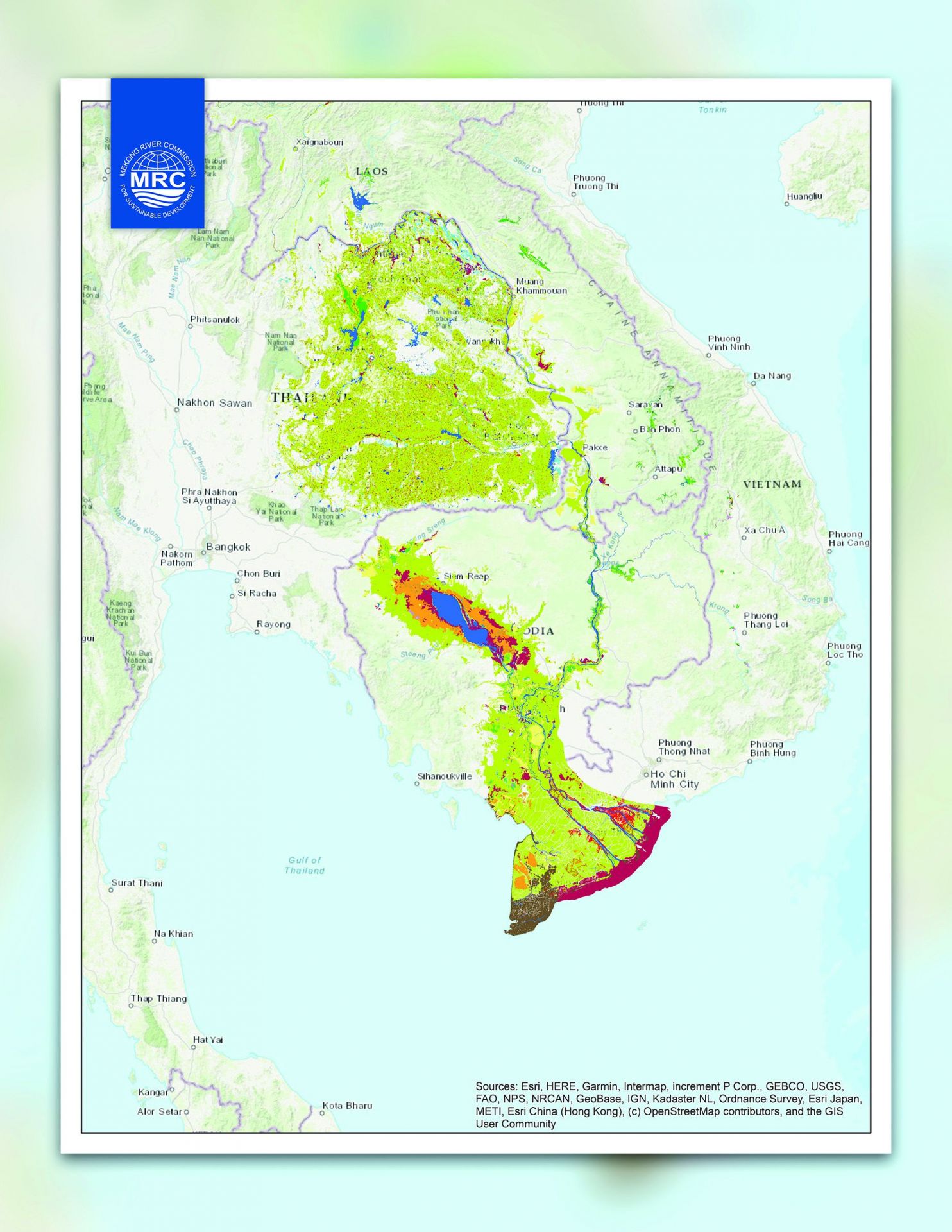
Figure 23. 2020 Map of the wetlands in the Lower Mekong Basin
Fish-Friendly Irrigation Systems In the LMB, the annual fish catch is estimated at 2.3 million tonnes (valued at USD 11 billion). However, the fisheries sector is threatened by tens of thousands of dams, dikes, weirs, and other water structures that have been built to store and control water for irrigation. Many of these structures make it difficult for fish to pass, affecting fish reproduction across the region. To help address the problem, the MRC and its partners worked on guidelines for fish-friendly irrigation systems and supported the testing by installing fish passes for selected irrigation schemes. The draft Guidelines for Fish-Friendly Irrigation Systems sets out a process for practitioners for identifying the highest priority irrigation structures that require repair and rehabilitation because they serve as barriers for fish passage. It also presents the design and construction process for practitioners to determine and implement the best fish passage solution for each of the high priority barriers. The MRC is revising the draft Guidelines based on the test results submitted by the countries.
Guidelines for Transboundary Environmental Impact Assessment in the Lower Mekong Basin The guidance sets out the process to facilitate MCs’ cooperation and communication in conducting EIAs for projects in irrigation, hydropower, and navigation, among others, with potential transboundary environmental impacts, while respecting the differences among their respective national EIA legislations and systems. Through seven regional meetings and nine national meetings from 2017–2019, the (draft) guidance was completed in September 2018 followed by a (draft) supplementary volume in May 2019. The supplementary volume provides a concise record of the long process leading to the development of the TbEIA Guidelines, including a summary of key lessons learned from the recent transboundary consultations related to major HPPs in LMB. As per the recommendation of MCs, the guidance can be used as a working document, which can be further amended based on experience gained from its practical applications.
Evidence of change

Figure 24. Outcome Evaluation Matrix
Note: The Matrix assesses outcome achievement based on output completion and the type of change that occurred – Outcome 3
Increase in knowledge and understanding As with every other product that the MRC has developed, the numerous technical meetings, training workshops, regional and national applications, and stakeholder consultations, held over several years for the Outcome 3 guidelines, have resulted in a significant increase in awareness, understanding, and capacity of potential users. For example, the increase in in-depth technical understanding and hence, openness of project proponents and developers can be largely attributed to the application of the PDG during the PNPCA PC of the first four mainstream HPPs. The RSAT has the additional benefit of having trained riparian RSAT facilitators going to each of the MCs to introduce RSAT and discuss specific national and local applications. This allowed them to develop a legal framework for assessing hydropower dams and other projects in Cambodia; evaluate the opportunity for a joint transboundary project between China and Lao PDR on fisheries management to mitigate impacts from hydropower development projects; identify potential improvements of existing HPPs in Thailand; and address flooding and dry conditions in the Cham Island Marine Protected Area due to impacts of the development of nearby HPPs. With respect to the Nam Ton River pilot area under which sustainable watershed management best practices were showcased at a local community level, the project has nonetheless contributed to a heightened regional understanding about watershed management. The lessons learned include: shifting from sector- to multisector-run management, using Participatory Water and Land Use Planning (PWLUP) as a mechanism to discuss, negotiate, and recommend watershed management practices for implementation with local communities and local administration officials; linking watershed management with forest plantation, protected areas, agricultural activities, and alternative livelihoods; and enhancing participation of communities, civil societies, and private businesses throughout the process. The MRC watershed management website is a repository of knowledge and experiences that are readily accessible for use.

“We appreciate the Preliminary Design Guidance (PDG). We used the PDG during our feasibility study to prepare the outline and concept designs for the Xayaburi hydropower project before we went to the PNPCA process. From my point of view, the PDG covers all main aspects of a new hydropower project. It is also quite easy and straightforward to apply. We used the PDG because it is the benchmark for the PNPCA. In our design, we applied international standards as well, but the PDG is special because it is designed to address specific issues of the Mekong River, and it was the only document available for the region” – Dr Michael Raeder, Deputy Managing Director, CK Power and Owner Representative from the Xayaburi Power Company Limited, 2017.
Use in regional and national planning and decision-making At the regional level, the use of the PDG and the RSAT for the PNPCA PC has been relatively mainstreamed. In particular, the RSAT hydropower sustainability criteria were used for Technical Review Report’s social-economic assessment, which was absent in the current PDG. The PDG is being used by the MRC Secretariat to assess technical compliance for all proposed mainstream dams during the PNPCA PC process, giving confidence to MCs and stakeholders that projects that pass through the MRC will be vetted, reviewed, improved, and monitored. At the national level, hydropower developers for all mainstream projects recognize the importance of the PDG and the need to comply, cementing the status of the MRC PDG as the standard guide in developing mainstream HPPs in the Lower Mekong. Other examples of MC-led applications of the MRC guidelines and products are as followers: • Cambodia is using the draft MRC TbEIA guidelines as a reference for developing its national environmental code and updating its national EIA systems to include a chapter on TbEIA. In addition, the Cambodian Ministry of Public Work and Transport is pilot-testing the TbEIA on a project entitled, “Channel Dredging for Waterway Improvement in Bassac River, a transboundary tributary between Cambodia and Viet Nam”. • Lao PDR updated its Decree on Environmental Impact Assessment on 31 January 2019 with the inclusion of chapters of TbEIA and Cumulative Impact Assessment (CIA). Article 22 of the Decree specifies that developers must implement the cumulative and transboundary impacts assessment as part of their studies, and in the case of cascading HPPs located on the mainstream Mekong, the project owners must implement according to the agreed terms and conditions as mentioned in the 1995 Mekong Agreement and other relevant regulations. • With respect to Waterborne Transportation Guidelines, Lao PDR is drafting their Law on Inland Waterway and improving their legislative system as part of harmonizing its waterway laws with Thailand. This is in line with the combined efforts of Lao PDR and Thailand to harmonize navigation rules on traffic safety, vessel safety and passenger protection, crew certification, search and rescue, and emergency response, port safety, waste management and contingency plans. Lao PDR and Thailand have also agreed to co-patrol the Mekong River regularly for traffic safety. • Since 2016, Chiang Saen port has been using the MRC guidelines for dangerous goods transportation and storage, waste management as a pilot project of the regional action plans for transportation of dangerous goods. These Guidelines are being applied to all the international and national vessels that are using the Chiang Saen port. • With respect to fish-friendly irrigation systems, demonstration projects on the construction and performance monitoring of low-head fish passage were conducted. These projects were in several locations: Pursat Province, Cambodia; Pakpeung village, Bolihamxay Province, Lao PDR; Huai Luang Basin, Udon Thani Province, Thailand; and Dak Lak Province, Viet Nam. These demonstration projects have resulted in immediate benefits to villagers, who say that they are catching more fish every day, which provides them with more stable incomes. Following these demonstration projects, the MCs have completed drafting their action plans for promoting fish passage installations in irrigation systems in their respective countries. • The wetland baseline maps produced from the wetland study will be used by Lao PDR for designating two of their wetlands, Nong Nga Wetland and Nong Fah, as Ramsar sites. Cambodia will be using the wetland maps for two of their wetland sites, Prek Toal and Stung Treng that have been designated as Ramsar sites.

Vertical slot fishway structure constructed in May 2019 at the Kbal Hong Weir in Pursat Province, Cambodia.
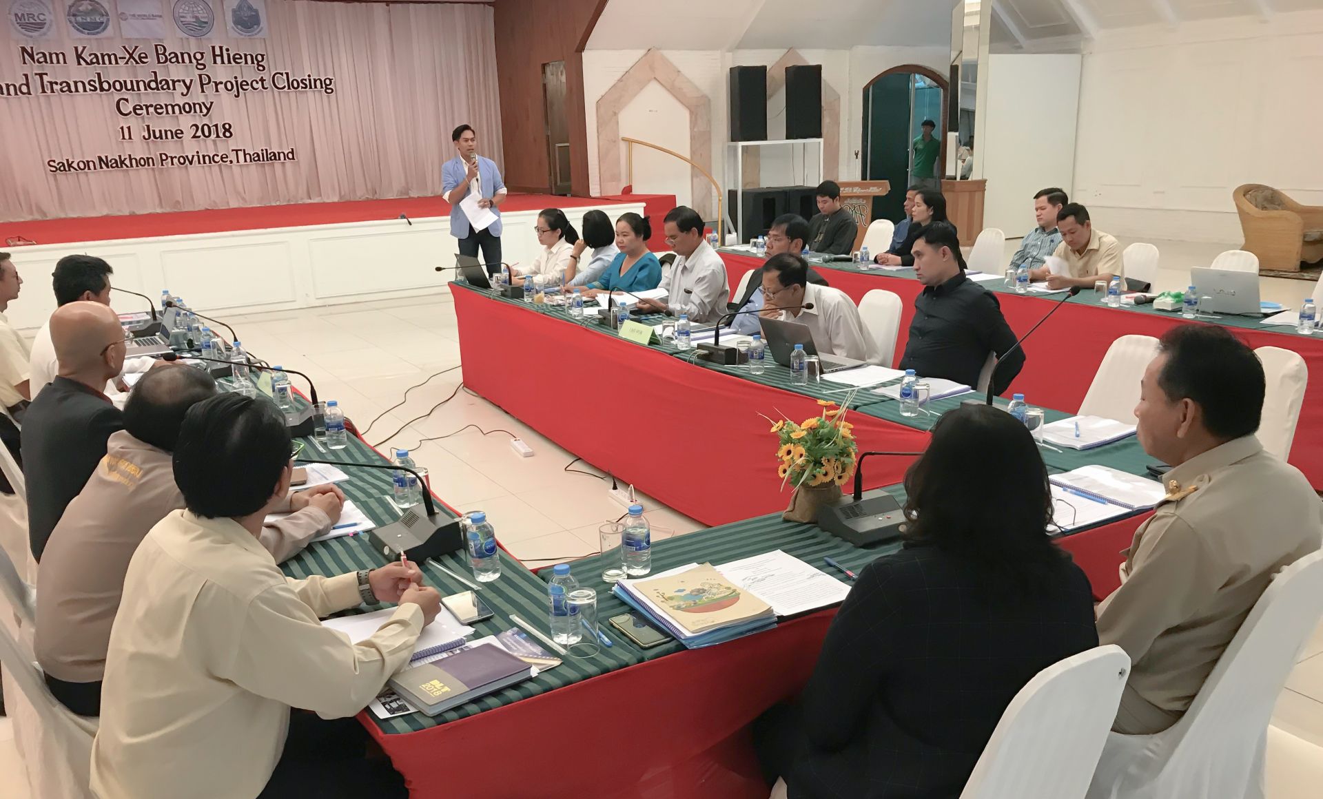
Officials and community representatives of the Lao-Thai wetland management project cerebrate its conclusion in an event in Sakon Nakhon, sharing its outcomes and lessons with other water user groups. held on 11 June 2018 in Sakon Nakhone Province, Thailand.