Regional conference sets to strengthen use of shared, real-time data on Mekong rainfall and water levels
SIEM REAP, Cambodia, 18 September 2012—Over 100 hydrologists and other water experts gathered in this historical town for a two-day regional symposium to discuss lessons learned and ways forward in sharing and using real-time hydro-meteorological data in the Mekong region.
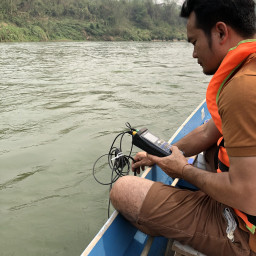
The symposium on hydro-meteorological networks, convened by the Mekong River Commission (MRC), reviews the past work and explores current needs in the region for accurate and readily- available hydro-meteorological data, which has been used by the MRC Member Countries, Cambodia, Lao PDR, Thailand and Viet Nam, for flood forecasting and warnings, inputs to modelling and improving the understanding of the dynamics of the river as well as other purposes such as navigation and fisheries. Getting near real-time data through the MRC’s regional platform means the countries can enhance their flood forecasting and warnings.
Providing networking opportunities, the symposium enables the countries, regional and international experts to share profound and subtle insights on the importance of this real-time data and strengthen future cooperation on regional data sharing.
Showcasing the full use of up-to-date and reliable hydro-meteorological data in the Lower Mekong Basin at the national and regional levels, the timing of the event also coincided with the completion of the MRC’s Hydro Meteorological Cycle Observation System (Mekong-HYCOS) project.
“I am pleased to note that the Mekong HYCOS project has succeeded with the establishment of an efficient, reliable and accurate near real-time rainfall and water level observation network covering observation sites on the Mekong mainstream and on tributaries in the four MRC Member Countries and China, and the transmission system,” said His Excellency Mr. Sin Niny, the Permanent Vice Chairman of the Cambodia National Mekong Committee as he delivered opening remarks at the event.
The information from the system is shared among the MRC Member Countries, helping them to get a more complete picture of water levels in different parts of the Mekong River system which includes the 4,900km-long mainstream and a vast network of tributaries.
The Mekong-HYCOS is a network that collects rainfall and water level data from 49 observation stations located throughout the region including 2 stations in China. It comprises 17 on the mainstream, 30 on tributaries and 2 tidal stations in the Mekong Delta.
“The cooperation between the Member Countries is what makes this system valuable, the ability to provide a regional picture of the water flows and a system in place for sharing this information”, said Hans Guttman, CEO of MRC Secretariat in his welcoming remarks, emphasising the value the Mekong-HYCOS brings to regional cooperation.
H.E. Niny also singled out Cambodia for praise with their establishment of state of the art equipment, known as the S-band Doppler Weather Radar station or “Techo SEN”, during 2010-2011, which is now fully operational.
“It has enabled Cambodia to produce and broadcast accurate and timely weather forecasts and warnings covering the entire country,” he said.
He added that the project was fully financed by the Royal Government of Cambodia and was realised through an agreement with Meteo France International.
The international symposium brought together ‘water people’ from all backgrounds and stakeholders from such diverse sectors as hydropower, environmental sciences, irrigation and agriculture to disaster management.
The Mekong-HYCOS project was funded by the government of France through the Agence Française de Développement and the Fonds Français pour l'Environnement Mondial with technical support from the World Meteorological Organisation.
Read the press release in Khmer.
Note to editors:
The MRC is the intergovernmental body responsible for cooperation on the sustainable management of the Mekong Basin whose members include Cambodia, Lao PDR, Thailand and Viet Nam. In dealing with this challenge, the commission looks across all sectors including sustaining fisheries, identifying opportunities for agriculture, maintaining freedom of navigation, flood management and preserving important ecosystems.
-END-