Mekong water levels to increase slightly with some stations reaching their alarm levels
Vientiane, Lao PDR, 21 August 2018 – The Mekong River’s water levels will slightly increase during the period 20 – 25 August, with an average rise of 0.40 meters in some stations along the mainstream. Many of them will reach their alarm level, a situation when a flood level is forecast within the next three days.
In Vientiane, the capital city of Lao PDR, the water level has reached its alarm level of 11.50 meters with the water recorded at 11.65 meters yesterday. But it is descending to a normal level from 11.43 meters on 21 August to 10.86 on 24 August.

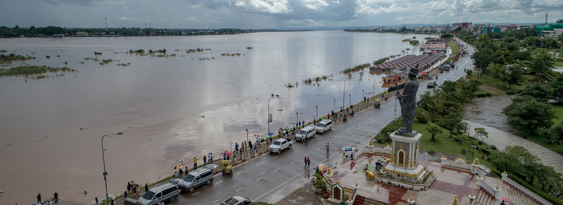
An aerial view of the Mekong River's water in Vientiane, showing the partial submergence of the newly built Nakharath City shopping stalls on 19 August. Bounphet Phommachanh & Jettana Viengsaly/MRC
In the downstream part of Lao PDR in Paksane, the water level has risen from 13.49 meters on 20 August to 13.95 on 21 August, passing its alarm level set at 13.50 meters. But the trend is moving downward from 13.81 meters on 22 August to 13.33 meters on 25 August. In Thakhek, the water level has moved from 12.60 meters on 20 August to 12.89 today. With this trend, it is expected to reach its alarm stage – set at 13 meters – when on 22 August the water rises to 13.19 meters. But this is going down to 12.89 meters on 25 August, representing a 0.3-meter decrease over night.
Further downstream of Lao PDR in Pakse, the alarm level of 11 meters is already on the record and this is expected to advance to the flood level, a situation where the water level reaches a full riverbank and overland flow of the low-lying area. The water at the station has increased from 11.68 meters on 20 August to 11.71 meters today. This is going to increase slightly steadily before reaching its flood level (set at 12 meters) on 24 and 25 August at 12.02 meters and 12.16 meters, respectively, representing an almost-half-meter increase over six days.
In Nong Khai of Thailand, the station reached its flood level set at 12.20 meters yesterday, but this is expected to decline over the forecasting period. The water level will gradually decrease from 12.67 meters on 20 August to 11.89 on 23 August.
In Nakhon Phanom of Thailand, the station yesterday reached its alarm situation set at 11.50 meters and this will slightly fluctuate over the next three days. The water level here will rise from 11.54 meters on 20 August to 12.13 on 22 August, which is 0.13 meters higher than its flood level. This will go down to 11.89 meters on 23 August.
Further downstream in Khong Chiam of Thailand, the water level has reached its alarm level set at 14.50 meters and this will continue to increase over the next three days. The water has increased from 14.06 meters on 20 August until reaching its flood level of 14.50 meters on 23 August when the water comes to 14.62 meters.
In Cambodia, water levels in all the eight monitoring stations will slightly increase. But only four among them will hit their alarm levels.
In Stung Treng, the water level was recorded at 10.76 meters yesterday against its 10.70-meter alarm level. This will move up to 11.15 meters on 25 August while its flood level is 12 meters. In Kratie, the water level on 20 August was 22.02 meters, a 0.02-meter higher than its alarm level. This will increase to 22.26 meters on 25 August, which is 0.74 meters lower than the station’s flood level. In Kampong Cham, the water will increase from 15.25 meters to 15.60 meters over the monitoring period. The station’s alarm level is 15.20 meters while the flood level is 16.20 meters.
Further downstream in Koh Khel, the station has already reached its alarm level of 7.40 meters. From 20 August, the water will increase steadily from 7.66 meters to 7.81 meters on 25 August, a 0.09-meter slightly lower than the flood level.
In Viet Nam, the two monitoring stations are all at their alarm levels, but will not reach their flood levels. In Tan Chau, whose alarm level is 3.50 meters, the water will increase from 3.59 meters on 20 August to 3.68 on 25 August. The station’s flood level is 4.50 meters. Over the same monitoring period, the water level in Chau Doc will rise from 3.10 to 3.25 meters. Chau Doc’s alarm level is three meters while its flood level is four.
The alarm and flood levels are both defined to predict possible dangers.
Analysis of the Mekong River Commission’s data reveals that the rising of water levels at some stations on the Mekong mainstream and tributaries is due in part to the tropical storm Bebinca. The storm late last week brought heavy rainfall between Laung Parabang and Paksane of Lao PDR and some parts in the Sekong, Se San and Srepok (3S) area.
The analysis also shows that the increase of water was detected in Luang Prabang, the upper part of the basin in Lao PDR, which then flowed to the lower reaches of the basin. This may be likely due to the release of water from reservoirs in tributaries in this province.
No indication of rising water levels was detached from any of the Chinese dam upstream.
Mekong flood forecasting page expanded
The MRC has expanded its Mekong flood forecasting page to make access to flood forecasting and early warming more convenient to the public. The expansion page is based on the current MRC’s Mekong flood forecasting site that is hosted on the main MRC’s website.
This expansion takes into account the need by some of television broadcasters in the MRC’s member countries to provide timely flood forecasting in the lower Mekong basin. A Thai TV broadcaster Thai Public Broadcasting Service (Thai PBS), for example, used this flood forecasting during its news reporting on the flood situation in the aftermath of the tropical storm Son-Tinh.

A screen grap from Thai PBS, showing a woman presenter discussing flood situation in Thailand, using the MRC’s flood forecasting, in the aftermath of the tropical storm Son-Tinh.
The new expansion page is now available in English but will soon be translated into all the four riparian languages of Khmer, Lao, Thai and Vietnamese.
During the flood season the MRC’s Regional Flood Management and Mitigation Center (RFMMC) provides daily flood forecasting for 22 key stations along the Mekong mainstream from Chiang Sean of Thailand to Tan Chau and Chau Doc of Viet Nam. The Commission also provides real-time information on warnings for flash floods from rainfall events over a given duration, known as Flash Flood Guidance, over the lower Mekong countries of Cambodia, Lao PDR, Thailand and Vietnam, based on Satellite Rainfall Estimate, a global hydro-estimator satellite system.
Hosted in Cambodia’s Phnom Penh, the RFMMC provides daily flood forecasting during the flood season betweenJune and October and weekly forecasting during the dry season between November and May. The forecast is usually made for a five-day period. Results from the forecast, including present water levels and additional flood information, are disseminated to different parties involved in flood and emergency management.
- Information on flood forecasting and flash flood guidance can be accessed at: http://www.mrcmekong.org/
- Information on water monitoring at the stations on the Mekong mainstream can also be accessed at: http://monitoring.mrcmekong.org/